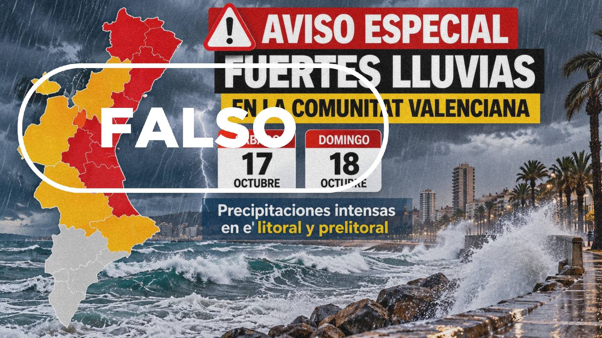
An infographic circulating on social media that warns of heavy rain across the Comunidad Valenciana on 17 and 18 October is not an official alert, according to RTVE.es. The image, which carries the headline "Aviso especial fuertes lluvias en la Comunitat Valenciana" and shows a map marked with red and orange warnings, has been shared online since 14 October. Both the Centro de Coordinación de Emergencias de la Generalitat and the Agencia Estatal de Meteorología (AEMET) told VerificaRTVE that the map did not come from them.
The false alert lands as a genuine and potentially dangerous weather situation develops. AEMET spokesperson Rubén del Campo told RTVE.es that an adverse meteorological episode is expected in the Comunidad Valenciana and in other large areas of eastern Spain and the Balearic Islands, caused by the arrival of a dana named Adam. Torrential showers and storms are possible in some parts of the region.
Why it matters
The fabricated map does not merely get the forecast wrong — it misplaces the risk. According to RTVE.es, the heaviest rainfall is expected in the south of the province of Valencia and the north of the province of Alicante, while the fake infographic concentrates its red and orange warnings on the north and centre of the region.
Mónica López, head of the El Tiempo department at TVE, told VerificaRTVE that such maps make disinformation worse and can put people in danger, because they show a situation that is not real while borrowing official-looking symbols. The concern is practical: residents who trust the wrong map may prepare for the wrong place, or dismiss the real warnings altogether.
What the official warnings actually say
As of the publication of RTVE.es's article, AEMET's warnings for those two days in the Comunidad Valenciana were yellow for Saturday and orange in the southern zone for Sunday. RTVE.es notes that the situation is changing quickly.
The Centro de Coordinación de Emergencias de la Generalitat Valenciana issued a meteorological alert on 14 October to flag the incoming conditions, but that notice did not announce orange or red warnings. A coordination meeting was scheduled for the afternoon of 16 October.
Del Campo said accumulations in the worst-affected areas could exceed 60 litres per square metre in under an hour, and even surpass 300 litres per square metre in less than 24 hours. He described these as very significant rainfall totals that could lead to flooding and rapid rises in riverbeds.
Why the map could not have been real
Two meteorologists explained to VerificaRTVE why the infographic's timing alone gives it away. López said AEMET publishes warnings on its website for three days only — today, tomorrow and the day after. Red warnings, she added, are normally activated with much less lead time, because a red alert triggers concrete actions such as sending out emergency notifications or prompting Protección Civil to take specific measures.
Rafael Armengot, of the Asociación Valenciana de Meteorología (AVAMET), gave the same account, telling VerificaRTVE that the protocol always works three days ahead. What can appear earlier, he said, are informative notes such as the one issued on 14 October flagging the arrival of the situation.
A reverse image search traced the infographic to a website that had reported on the Generalitat's special emergency notice. RTVE.es verified that the image was generated with artificial intelligence, specifically using one of OpenAI's models.
The same search, combined with checks of official AEMET and municipal social media accounts, turned up genuine maps carrying similar warnings — but dated 1 October. On that day AEMET flagged rain, storm and coastal warnings, with the maximum red level in the interior north of Castellón and along the entire Valencia coastline, a different distribution from what the fake weekend map shows. The Generalitat also posted about that situation, and several Valencian town councils shared their own warning maps with residents.
What to do instead
Del Campo set out a series of recommendations for the public ahead of the dana. He advised people to avoid low-lying and flood-prone areas, to stay away from riverbeds even when they are dry, and never to try to cross them, because water levels can rise very fast. He added that following instructions from Protección Civil authorities remains essential.
The experts consulted by VerificaRTVE agreed on one point: official sources should always be the reference. For this weekend, that means AEMET's own warnings and updates from the Centro de Coordinación de Emergencias, not maps forwarded through social media.
Forecasts for the region remain subject to change, and the coordination meeting on the afternoon of 16 October may bring revised warnings. Residents in the south of Valencia province and northern Alicante should watch for official updates as the dana approaches.